Braidwood Floodplain Risk Management Plan and Study
Share on FacebookShare on TwitterShare on LinkedinEmail this link
Consultation has concluded
The aim of the Braidwood Floodplain Risk Management Study and Plan (FRMS&P) is to review and assess the impacts of flooding within Braidwood on existing development and to a framework to manage flood liable land. The FRMS&P has been produced following current best practice floodplain management principles.
The Study and Plan has been jointly funded between Queanbeyan-Palerang Regional Council and the NSW Office of Environment and Heritage.
The Floodplain Risk Management Committee is comprised of select Councillors, relevant State Government agencies and community representatives.
The Plan recommends a program of works and measures which will over time reduce the social, environmental and economic impacts of flooding at Braidwood. The Study and Plan built on the results of the previous Braidwood Creeks Flood Study (completed in 2005), which defined flooding patterns and flood levels in Braidwood under present day conditions.
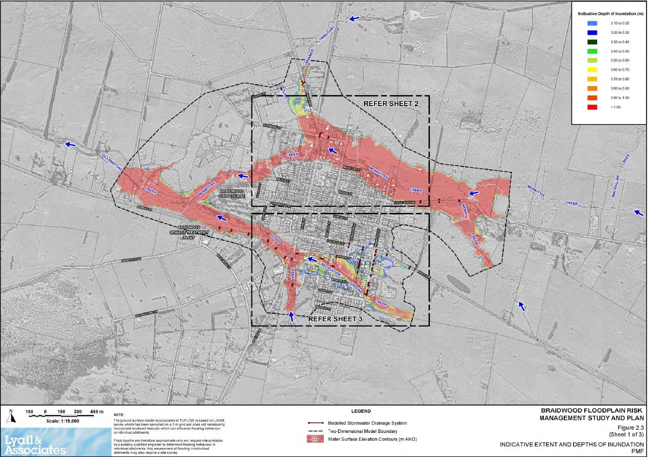
Figures 2.2 and 2.3 (refer to the photo gallery and attached documents) shows the indicative extent of the 1% (1 in a 100 year storm) annual exceedance probability (AEP) flood along Gillamatong, Monkittee, Flood and Recreation Ground Creeks, as well as the extent of the Probable Maximum Flood (PMF). The PMF is the largest flood that could conceivably occur at Braidwood and previous methodology considered occurrences similar to every 500 years.
The Study and Plan reviews and considers the following flood management measures:
Management of vegetation along the creek corridors to provide flood mitigation, stability, aesthetic and habitat benefits
Widening of watercourses
Construction of detention basins on vacant land upstream of Monkittee Street
Improve the stormwater system within the town area
Construct permanent levees along the creeks to contain floodwaters
Voluntary purchase of residential property in high hazard floodway areas
Provide funding or subsidies to raise houses above the major flood level in high hazard flood storage and low hazard floodway areas
Specify controls over future development in flood liable areas (e.g. controls on extent of filling, minimum floor levels, etc.)
Improve flood warning and evacuation procedures both before and during a flood
Community education, participation and flood awareness programs
Provide a Planning Certificate to purchasers in flood prone areas stating that the property is flood affected
The aim of the Braidwood Floodplain Risk Management Study and Plan (FRMS&P) is to review and assess the impacts of flooding within Braidwood on existing development and to a framework to manage flood liable land. The FRMS&P has been produced following current best practice floodplain management principles.
The Study and Plan has been jointly funded between Queanbeyan-Palerang Regional Council and the NSW Office of Environment and Heritage.
The Floodplain Risk Management Committee is comprised of select Councillors, relevant State Government agencies and community representatives.
The Plan recommends a program of works and measures which will over time reduce the social, environmental and economic impacts of flooding at Braidwood. The Study and Plan built on the results of the previous Braidwood Creeks Flood Study (completed in 2005), which defined flooding patterns and flood levels in Braidwood under present day conditions.
Figures 2.2 and 2.3 (refer to the photo gallery and attached documents) shows the indicative extent of the 1% (1 in a 100 year storm) annual exceedance probability (AEP) flood along Gillamatong, Monkittee, Flood and Recreation Ground Creeks, as well as the extent of the Probable Maximum Flood (PMF). The PMF is the largest flood that could conceivably occur at Braidwood and previous methodology considered occurrences similar to every 500 years.
The Study and Plan reviews and considers the following flood management measures:
Management of vegetation along the creek corridors to provide flood mitigation, stability, aesthetic and habitat benefits
Widening of watercourses
Construction of detention basins on vacant land upstream of Monkittee Street
Improve the stormwater system within the town area
Construct permanent levees along the creeks to contain floodwaters
Voluntary purchase of residential property in high hazard floodway areas
Provide funding or subsidies to raise houses above the major flood level in high hazard flood storage and low hazard floodway areas
Specify controls over future development in flood liable areas (e.g. controls on extent of filling, minimum floor levels, etc.)
Improve flood warning and evacuation procedures both before and during a flood
Community education, participation and flood awareness programs
Provide a Planning Certificate to purchasers in flood prone areas stating that the property is flood affected